About Cuckfield
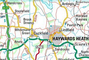
Cuckfield is a village situated 12 miles from the south coast at Brighton and 38 miles from London, set high on the Weald of Sussex. It is surrounded by beautiful countryside with famous gardens and National Trust properties nearby. There is easy access to the A23/M23 motorway and the mainline railway station at Haywards Heath. To the northeast lies the wild moorland of the Ashdown Forest and to the south is the beauty of the South Downs.
The Dunlop Motorists Guide for August 1920 describes Cuckfield:
Pleasant old-world town, very quiet, and reclining on the older Brighton Road, 37 miles from London, 14 miles from Brighton. The wholly modern town of Haywards Heath adjoins on the East, a place created by travelling facilities offered by The London, Brighton and South Coast Railway. But old Cuckfield remains unaffected by this modern neighbour. The interesting church is 13th and 14th century. Outside the town is Cuckfield Place, ancient seat of the Sergisons. Picturesque avenue approach, with 17th century gatehouse, brought from Slougham Place.
London, 37 miles. Population, 2698. Market, Tues. Early closing, Wed.
The book can be read on the Internet Archive
Cuckfield still keeps plenty of its small country-town character. It is built on the side of a hill with a steep High Street running down to old houses and shops behind which the tall spire of Holy Trinity Church rises high above.
The bones of an iguanadon were found in 1822 by Mary Ann Mantell, wife of Gideon Mantell, on the northern edge and to the south there was a bronze/iron age settlement.
William I divided Sussex into six parts, called “rapes”. The rapes were strips of land running from forest land in the north, cultivated and habitable land nearer the Downs and a port upon the coast. Cuckfield fell with the Rape of Lewes, which stretched from Lower Beeding in the west to Horsted Keynes in the east. It was dominated by the castle at Lewes and stretched down to Seaford as the seaport. The Rape of Lewes was granted to William de Warenne who enjoyed the popular sport of hunting. Part of the forest was cleared and enclosed as a “park”. It was in this park that he had built a hunting lodge and a chapel. The settlement was called Kukefeld and it was given by William as an endowment to the Cluniac Priory of St Pancras at Lewes. In 1091 their son, William, second Earl of Warenne, confirmed by charter the gift his parents had made.
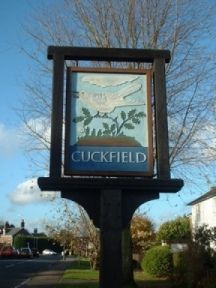
Pronounced Cookfield, it dates back to Saxon times. It was first written Kukefeld in 1092, followed by Cucufeld in 1121. Cuckoos were called cuc or cuccu by the Normans so it is thought the name could mean “a clearing full of cuckoos”. An alternative, but less poetic, meaning is “land surrounded by a quickset hedge”. On the outskirts is a sign showing a cuckoo on a tree.
Cuckfield has experienced periods of importance and decline and was once the market town and key administrative centre in the district. The older part of Cuckfield village lies chiefly along the main street, which runs north and south, with a deflection at the south end to avoid the church, the old school, and other buildings about them. The High Street is lined with attractive 16th and 17th century houses. The Rose and Crown Inn, at the north corner of the loop-road to Haywards Heath, retains a late-16th-century projecting chimney-stack at its north end. Macaulay House, formerly Ockenden House and now Ockenden Manor, the seat of the Burrell family, stands west of the village and is mostly of 16th-century timber-framing but has a short wing at the south end, of stone, probably added after a fire in 1608. There are in the village a number of houses which retain chimneystacks and other features of the 17th century, as, for instance, Marshall’s, which has an ashlar front, Maltman’s and Maberley’s, which are timber-framed with tile-hanging, and a group of cottages near the church.
In the 16th century it was a thriving centre of the local iron industry that thrived in the forests. Wealden clay was rich in ironstone and there was a plentiful supply of water to power equipment and trees for fuel. It went into decline when the industry moved to the north of England, but a great deal of money had been made by the iron men and the wealth was invested in local properties.
The majority of townspeople were tenants or or employees of either the Sergisons at Cuckfield Place since 1691 or the Burrells of Ockendon House since 1659 who were the two families who owned the land. There are monuments to both families inside Holy Trinity church.
It flourished again in the late 18th century and prior to the construction of the Turnpike Road in 1807 there was a major staging post at the King’s Head (now a residential mews) on the main route from London to Brighton. Cuckfield lost its importance in 1840 with the advent of the railway line which by passed the town as local landlords objected to its route; it went through Haywards Heath instead .
The population in 1991 was 2,845. This had increased to 3,500 when the 2011 census was taken.